Thurian Age Maps and Me: Part One
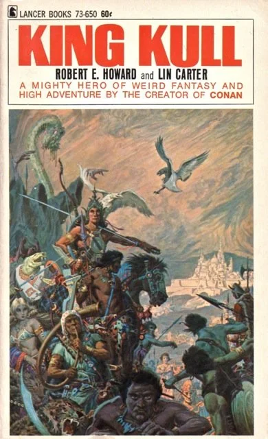
The 1967 Lancer edition with a cover painting by Roy G. Krenkel. One can see a very early portrait of ST Joshi in the immediate foreground.
According to my mom, I’ve loved maps since I was four years old. I’ve been reading actual fantasy since I was seven years old. That Gnome Press edition of Conan the Conqueror with the David Kyle map of the Hyborian Age blew my mind. You can check out the full story in Robert E. Howard Changed My Life. From there, I treasured and devoured fantasy maps where and when I found them.
I bought Marvel's Kull the Destroyer #16 in 1976. That comic and the map in the letters section gave me a glimpse into REH's Thurian Age. However, I want to start this series at the start. That would be Lancer's King Kull in 1967. This edition was collected and edited by Lin Carter. It was a landmark in its own way.
Up to that point, the Kull stories publically available were basically a cult thing among Howard devotees. While "The Shadow Kingdom" had caused a sensation--being praised by the likes of A. Merritt and Lovecraft--Weird Tales only published two other tales of Kull. Even Derleth's Arkham House, which did much to get the word out on REH in the post-World War II era, only reprinted the same tales.
So, here comes Lin Carter. Already a redoubtable scholar of fantasy--and also the first author to get a full, stand-alone paperback S&S novel published with 1965's The Wizard of Lemuria--Carter was tapped by L. Sprague de Camp to help out writing pastiches for the Lancer Conan volumes. It appears that Spraguey brought on Lin for Conan and then offered him the chance to do the Lancer collection of Kull tales. It should be noted here, once again, that de Camp never, ever displayed more than a passing interest in Kull or any of Howard's other non-Conan heroes. I'll look at that more in a future blog entry.

Lin Carter: Fantasy editor, scholar and cartographer.
Carter was handed a treasure-trove of Kull manuscripts--presumably by Glenn Lord--and he ran with them. He completed three Howard fragments and also provided a map, which he titled "King Kull's World".
Let me preface my criticisms by stating that I consider Lin Carter to be a good fantasy cartographer. By that, I mean--while somewhat crude--he is generally accurate and that his maps look 'old-fashioned'. Nowadays, there are many fantasy maps out there that are accurate, but they look like they're taken from the US Geological Survey. Fantasy maps--in my opinion--should convey a sense of 'otherwhen' and 'otherwhere'. They should also be artistically pleasing. Otherwise, I am taken 'out of' the story/map when consulting them.
I should also state--briefly--that I consider fantasy maps to be, if not essential, then highly helpful when reading any fantasy tales set in imaginary or unknown lands.
Carter's map of “King Kull's World” is exactly what it purports to be, in a way. Before I explain that, I'll quote from Gary Romeo's website, which is where I got the scan for Carter's map:
'In the Lancer paperback, the map is presented just before “Prolog” which is, as said above, a truncated version of REH’s “The Hyborian Age.” REH’s disclaimer paragraph that starts “Nothing in this article is to be considered as an attempt to advance any theory in opposition to accepted history.” is cut. The “Prolog” begins with “Of that epoch known by the Nemedian Chroniclers as the Pre-Cataclysmic Age, little is known except the latter part, and that is veiled in the mists of legendry.” And it ends with the line, “Of the bickerings of the kingdoms, and the wars between Valusia and Commoria, as well as the conquests by which the Atlanteans founded a kingdom on the mainland, there are more legends than accurate history.”
When reading the “Prolog” along with viewing Lin Carter’s map, you can see that a lot of countries are missing from Lin’s map. The Kirk map is significantly better. Carter’s map was a noble first try and does convey enough of the landscape to enhance enjoyment of the stories in this collection.'
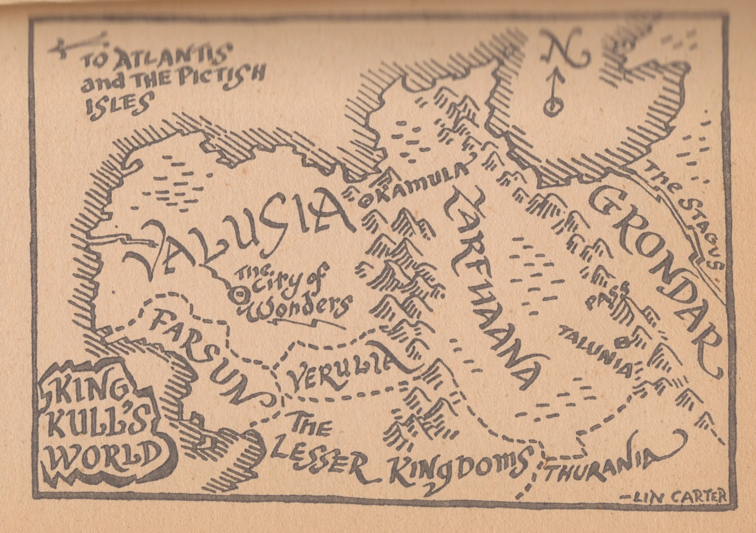
The 'Kirk map' refers to the classic Tim Kirk map in the Bantam 1978 Kull edition.
Romeo states:
"When reading the 'Prolog' along with viewing Lin Carter’s map, you can see that a lot of countries are missing from Lin’s map."
The simple explanation for that is Lin left out the kingdoms not actually mentioned in the Kull stories within King Kull. Those would be Thule, Commoria and Kamelia. I can see doing that if Lin was legally prevented from mentioning those three kingdoms, which were first typed on paper by Robert E. Howard in 1932, when he wrote his several versions of the "The Hyborian Age". They do not make an appearance in the actual Kull yarns. At all.
The mystery arises from the fact that Carter obviously had legal access to/use of the data in "The Hyborian Age" and still drew the map the way he did. It is as if someone got access to all of the Kull manuscripts in 1930 and drew a map based off of them. Even then, it places Verulia where it obviously--according to REH--could not be.
I give props to Lin Carter as a pioneer. I also thank Gary Romeo for getting Lin's map up on the Internet.